Update infromation:
2024/05/01 JST License information was added.
The contents of this website are subject to change without notice.
Citation
Please cite the following paper for publishing your results using the data of this global terrain classification.Junko Iwahashi, Izumi Kamiya, Masashi Matsuoka and Dai Yamazaki (2018) Global terrain classification using 280 m DEMs: segmentation, clustering, and reclassification. Progress in Earth and Planetary Science, 5:1. https://doi.org/10.1186/s40645-017-0157-2
LINK (open access by SpringerOpen)
License
This work was originally supported by JSPS KAKENHI Grant Number JP15K01176.Based on the concept of JSPS KAKENHI which encourages open access, we believe the data published on this site is licensed under a Creative Commons CC-BY 4.0.
When you use the data in your paper or presentation or product, please be sure to cite the above paper (Iwahashi et al., 2018).
7.5 arc-second global GeoTIFF (Geographic, WGS1984)
This GeoTIFF file was converted by Dr. Tomislav Hengl (ISRIC) from the shapefiles of the 15 terrain groups of Iwahashi et al. (2018). Thanks to Dr. Hengl, the GeoTIFF file is published here.DOWNLOAD
Polygon shapefiles for each tile (Lambert azimuthal equal-area, WGS1984)
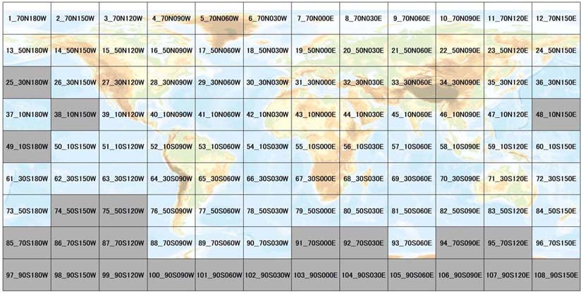
Gray tiles: No Data
The attributes of shapefiles include not only the 15 terrain groups (GROUP; grouped by Japanese geomorphological and geological maps) but also the original 40 classes (CLASS).
The tile size is 30 degree (EW) x 20 degree (NS). Map projection is Lambert azimuthal equal-area (the central meridian and latitude of origin: the center point for each tile).
Please check the index map and download below zip files. Legend of the terrain groups is attached in the zip file.
01_70N180W 02_70N150W 03_70N120W 04_70N090W 05_70N060W 06_70N030W 07_70N000E 08_70N030E 09_70N060E 10_70N090E 11_70N120E 12_70N150E 13_50N180W 14_50N150W 15_50N120W 16_50N090W 17_50N060W 18_50N030W 19_50N000E 20_50N030E 21_50N060E 22_50N090E 23_50N120E 24_50N150E 26_30N150W 27_30N120W 28_30N090W 29_30N060W 30_30N030W 31_30N000E 32_30N030E 33_30N060E 34_30N090E 35_30N120E 36_30N150E 37_10N180W 39_10N120W 40_10N090W 41_10N060W 42_10N030W 43_10N000E 44_10N030E 45_10N060E 46_10N090E 47_10N120E 50_10S150W 51_10S120W 52_10S090W 53_10S060W 54_10S030W 55_10S000E 56_10S030E 57_10S060E 58_10S090E 59_10S120E 60_10S150E 61_30S180W 62_30S150W 63_30S120W 64_30S090W 65_30S060W 66_30S030W 67_30S000E 68_30S030E 69_30S060E 70_30S090E 71_30S120E 72_30S150E 73_50S180W 76_50S090W 77_50S060W 78_50S030W 79_50S000E 80_50S030E 81_50S060E 82_50S090E 83_50S120E 84_50S150E 88_70S090W 89_70S060W 90_70S030W 93_70S060E 96_70S150E
Additional information
This study was supported by JSPS KAKENHI 15K01176.The global terrain classification was created from 280 m DEMs using MERIT DEM (Multi-Error-Removed Improved-Terrain DEM; Yamazaki et al., 2017).
GlobCover 2009 was used to mask water bodies in most areas.
Iwahashi et al. (2018) is an update of Iwahashi and Pike (2007) (LINK to the data download site).
For more information, please read the paper, or contact to the corresponding author (Junko Iwahashi).
Following research
Please check the following research.Japan, 30m resolution: Classification of Topography using 30 m DEM of Japan (Iwahashi et al., 2021)
Global, 90m resolution: Global polygons for terrain classification divided into uniform slopes and basins (Iwahashi and Yamazaki, 2022)